

January 2023
Route 89 Between Page and Bitter Springs, Arizona
The Navajo Nation lands border the Colorado River to the east. The town of Page, Arizona was carved out of the Nation when the construction of the Glen Canyon Dam was started in 1956. Route 89 is the primary road to reach the dam from the South. It is also the primary route used to access the North Rim of the Grand Canyon.
This image was taken, nearly at road level, right before Antelope Pass. The road then drops nearly a thousand feet before reaching Bitter Springs.

February 2023
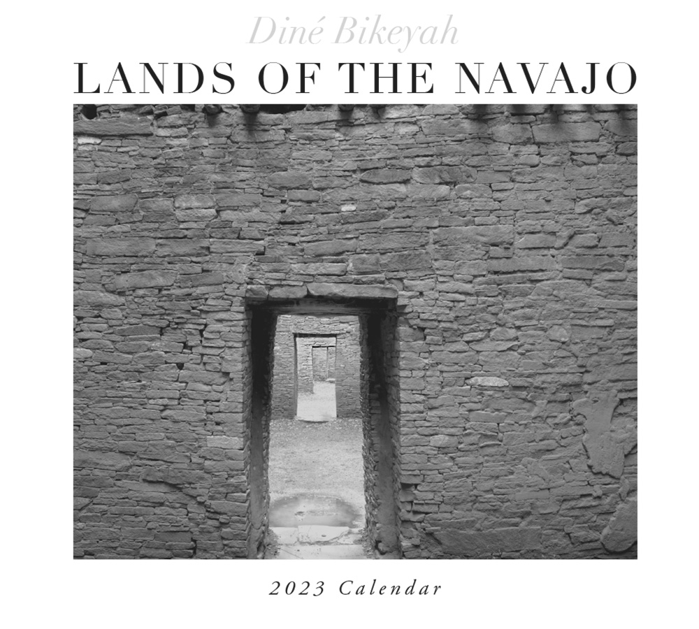
Inside Pueblo Bonito, the Largest of the Chaco Canyon Great Houses, Built Circa 800-1100 AD
Navajo people have a cultural relationship with Pueblo Bonito associated with their mythology and origin stories. In general, Chaco Canyon, and in particular, Pueblo Bonito, are viewed in negative terms by the Diné relative to the Gambler and Coyote (Trickster). Navajo respect Chaco Canyon and do visit it, but very rarely will ever go inside the buildings.
The image is taken inside Pueblo Bonito. Interconnecting rooms are joined by doorways but the rooms were not used for any known purpose. They were simply the outside layer of rooms. However, they do make possible a wonderful image. The logs seen at the top of the image were dated to last the part of the 10th century. The logs were the ceiling support.
If you are unfamiliar with Chaco Canyon, see this link to the National Park website: https://www.nps.gov/chcu/index.htm

March 2023
Ventana Grande, Southeast of Many Farms, Arizona
This image was the last image taken by BigBuzz before its fatal crash. BigBuzz was a DJI industrial drone: Matrice 600 & Ronin-MX gimbal with a payload capacity of 10 lbs. It was six years old when it crashed.
The Ventanas (windows) are in an area west of Canyon de Chelly National Monument. It is named for its extensive set of red rock arches in weather-carved Entrada sandstone. The scene shows differential erosion… notice all the indentations in the top of the butte. Every indentation has arches! Many are nearly impossible to get to.

April 2023
Ventana Grande, Southeast of Many Farms, Arizona
This image was the last image taken by BigBuzz before its fatal crash. BigBuzz was a DJI industrial drone: Matrice 600 & Ronin-MX gimbal with a payload capacity of 10 lbs. It was six years old when it crashed.
The Ventanas (windows) are in an area west of Canyon de Chelly National Monument. It is named for its extensive set of red rock arches in weather-carved Entrada sandstone. The scene shows differential erosion… notice all the indentations in the top of the butte. Every indentation has arches! Many are nearly impossible to get to.

May 2023
Turquoise Mountain, Photographed from Sandstone Bluffs, El Malpais National Monument, New Mexico
Turquoise Mountain (aka Blue Bead Mountain) is one of the four sacred Navajo mountains. Its peak is at 11,305 feet. Non-Navajo call it Mt. Taylor.
The image was photographed from Sandstone Bluffs, a marked and defined area in the El Malpais National Monument. Malpais, bad country in Spanish, is mostly covered in lava.

June 2023
Dancing Sheep Petroglyph, Circa 950 AD, Northern Arizona
I took this photograph in 2006 and it is one of my favorite rock art scenes. I have been reluctant to use it in the calendar because it is nearly identical to an Ansel Adams image used in his calendar.
I finally got over it. So here it is.

July 2023
Confluence of the Paria River and the Colorado River Below Glen Canyon Dam, Arizona
This image was taken on the west side of the rivers. Navajo lands are on the other side, the river being the border. The Paria River flows out of the Vermillion Cliffs National Monument, home to Coyote Buttes. My work in Coyote Buttes is on this website.
White rocks in the foreground were almost always underwater, the reason they are bleached out. As has been written about extensively, a two-decade drought has severely reduced the flow of the Colorado river below the Glen Canyon Dam exposing the water-bleached areas… aka, the “bathtub ring”.

August 2023
Kin Bieola Chocoan Great House
Navajo for “house in which wind whirls”
Primarily built 1100-1120 AD
Kin Bineola is a late-stage Great House, twelve miles west of “Downtown Chaco”. It is massive with a construction that differed somewhat from other great houses in that it is not a D shape. There was originally a straight tall wall in the front of the rest of the structure with two courtyards as is seen in the image. The back wall is also straight rather than curved like a D.
You cannot no longer visit this ruin. The National Park Service decided it was too difficult to protect. It has not been excavated and probably never will be.

September 2023
The Fall Road Back to School, Northwestern Arizona
This year, I have chosen a scenic road on the Reservation as the September back-to-school image.
The Reservation is 27,000+ square miles and is larger than 10 US states. While it is crisscrossed with many paved road, primarily highways, most roads are dirt. This is one beautiful example as it flows into the horizon.

October 2023
Old and New Navajo Bridge over the Colorado River, Arizona
These bridges are on Route 89A, 75 to 100 miles north of the North Rim of the Grand Canyon. It is the only way to get to this side of the Marble Canyon if you are coming from the south.
The original bridge on the left was opened in January 1929. It was only 18 feet wide. As vehicles became larger and heavier a new bridge needed to be built. The new bridge opened in 1995 and is 44 feet wide.
Both bridges are nearly 500 feet above the Colorado River. The sandstone cliffs on the west side are home to the reintroduced California condor with its 10-foot wingspan. The reintroduction is managed by the Peregrine Fund, which is dedicated to conserving birds of prey worldwide.

November 2023
Monument Valley Navajo Tribal Park Photographed from Hunts Mesa, Arizona
This image, taken nearly 20 years ago, was photographed on my first trip to Hunts Mesa with Tom Phillips, a Navajo guide who later became a close friend. At that time, getting to Hunts Mesa was extremely difficult due to steep sand dunes and thin mountain-clinging roads. Today it is easier, and several guides offer day trips and overnight camping stays.
The mesa provides, far and away, the single best panoramic view of Monument Valley.

December 2023
Wing Detail of the Rock With Wings (Shiprock), New Mexico
Each year, the December image is of Shiprock, a volcanic plug in the Four Corners region. It is the most often shown image representing the state of New Mexico. It is sacred to the Navajo and climbing the mountain is expressly forbidden.
The Navajo name is Tsé Bitʼaʼí, rock with wings. Many of the calendar images I have used of Shiprock were shot by hanging out of an airplane in order to photograph the peak and the wings. In May 2021 I had this concept to shoot one of the wings using a drone in order to show the size of the wing and perspective with the main formation. Months later, I saw the image again on TV! It was in the last scene of the Apple TV+ movie starring Tom Hanks called Finch. That scene was also shot with a drone. (I really enjoyed the movie!)